
If the Earth were a smooth solid and not rotation, understanding wind systems would be easy. Heat would rise in the equatorial regions and warm, high level winds would blow due north and south returning towards the equator as cool winds at the surface. But the earth is spinning and has oceans and continents, hence the more, complex patterns. The earth’s rotations pull the equator bound winds to the west, creating the trade winds from the northeast in the region of the Tropic of Cancer and from the southeast at the Tropic of Capricorn. Other circulation cells provide the prevailing westerlies in the Northern Hemisphere and easterlies in the Southern Hemisphere. This is further complicated by the continents. During the Northern Hemisphere winter, cold continental masses of Asia and North America. In July those continents are warmer and the air flow is reversed. The most spectacular example of this is the monsoon; warm, moist air blows into Asia from the Indian Ocean, depositing heavy rain as it crosses the Indian subcontinent and rises over the Himalayas.
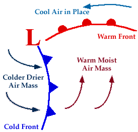
Much of the weather at temperate latitudes is dominated by the interaction between masses of cold and warm air. They meet at what is known as a front, but do not mix. At a warm front, warm air rises above cold, creating a low pressure system. Moisture in the warm air builds into clouds which may produce light precipitation. At a cold front cold air wedges in under warm air, clouds build again, this time resulting in heavier, more prolonged precipitation. As the warm air rises, the front eventually combine and lift off the ground to form what is known as a occluded front. The warm air then rises more slowly, the low pressure system weakens and any precipitation eases off.


0 comments:
Post a Comment
Note: Only a member of this blog may post a comment.