Showing posts with label Earth science and The Universe. Show all posts

Tuesday, April 19, 2011

Origin of Life

The earliest traces of the life on earth have been found in the rocks about 3.5 billion years old. They are layered structures similar to those formed by some of today’s marine bacteria, and it is generally accepted that the first forms of life were some kind of bacteria. We do not know exactly how these first living things or organisms were produced, and probably never will, but laboratory experiments suggest that energy from lightning or from ultra violet radiation could have caused gases, like methane and ammonia to combine with simple minerals to produce proteins and other building blocks of life such reactions would probably have taken place in shallow water.
As more and more life’s building blocks were formed, they inevitably mingled and reacted with each other to form new compounds. Eventually, a chance combination gave rise to a molecule of DNA, a self replicating material that is the basis of all living matter. Here, perhaps, was the “spark of life” and the scene was then set for the appearance of the first cells and the subsequent evolution of all life on Earth. Since the beginning of life, millions of different kinds of organisms have come and gone. It is estimated that there are about 300,000 different kinds of plants in the world at the present time, and there may be over five million kinds of animals- or some estimates, nearer ten million – although only a little over a million of these have so far been described.

Friday, February 25, 2011

Map Making

A map is a schematic representation of an area. Maps are primarily used to help locate places or plan a journey, and can range from a plan of a farm to a map of the world. Maps may also be used to illustrate information about a particular area; for example, distribution of population, resources or climate. These specialized maps are known as thematic maps.

                In any map the way reality is represented depends on the amount of information it contains, the used of diagrams and other graphic devices, and the scale- the size of the map in relation to the area it shows. The oldest surviving maps were made by the Babylonians more than 4000 years ago. Many ancient mapmakers assumed that the Earth was flat, but the circumnavigation of the globe in the 15th century led to great improvements in the accuracy of map making.  

                Maps show a range of information by the use of symbols and approximations. The first stage of map making is to construct a network of fixed points, from which everything else can be located. That way subsequent error will not accumulate and cause major distortions.  Before map makers had aerial photographs and satellite images to help them, the fixed points were plotted by a process called triangulation. Triangulation points are set up on landmarks such as hilltops. From the angles between these points, distance can be calculated without the need to take measurements on the ground. Adding vertical angle measurements give the heights. The height information on maps is normally shown as contours- lines linking points of the same elevation. It was by setting up a triangulation system across India from the coast to the Himalayas that cartographers first established the Mount Everest was the highest mountain in the world.  Today, satellite images provide the framework and maps are stored on computer so that they can be updated quickly without the need for redrawing.   

Wednesday, February 23, 2011

Stop Climate Change


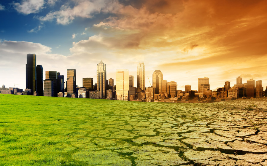
            The Earth’s atmosphere is now changing more quickly than at any time in the past. In the last 150 years there had been a 25 percent increase in carbon dioxide and a 100 percent increase in methane in the atmosphere, largely as a result of the burning of fossil fuels, the expansion of agriculture and rapid deforestation.

Over the same period, the world‘s climate changed by an average of 0.05 degree Centigrade, as green house gases trap the Sun’s heat within the atmosphere. Computer models predict a continued warming of 0.5 degree a decade unless steps are taken to limit emissions. The climate change would be greater were it not for pollutants such as sulphur dioxide which scatter sunlight back into space. Other gases- notably CFCs from fridges, aerosols and fire extinguishers- are damaging the tenuous layer of ozone in the stratosphere which screens out ultra violet radiation from the Sun. 

Steps have been taken to phase out CFCs. They are also powerful greenhouse gases, but legislation to reduce other green house gases will be harder to implement since the practices that produce them are central to modern life. Many nations have pledged to reduce emissions to their 1990 levels, but stronger measures will be needed for stop climate change.

Monday, February 21, 2011

Causes of Climate change

Humans have farmed for thousands of years but in just the last few decades burgeoning populations have called for more agricultural ingenuity than ever before and subsequently agriculture becomes one of the causes of climate change. The breeding of new crop varieties, the use of fertilizers and pesticides and the bringing of more and more land under cultivation have kept production ahead of population growth throughout most of history which are the main causes of Climate change.. Since 1985, however, the limit seems to have been reached and per capita grain production has started to fall.
                In 1987 world grain reserves were sufficient for 100 days; by 1989 there were only enough for 54 days, yet there are 100 million more people to feed every year. There have been hidden costs to the increases in productivity. It is thought that about 40000 people in the developing world die of pesticide poisoning every year and the pesticides also one of the environment hazards.  Twenty four billion tones of top soil are lost from crop lands each year, eroded by wind and water.
                Irrigation is lowering the water table beneath eight states in the Great Plains of the USA by a meter a year, and the diversion of rivers for irrigation in the former Soviet has reduced the Aral Sea to about a third of the size it was 25 years ago. One tenth of the Earth’s land surface is currently given over to agriculture but there will have to be yet further changes before food production is sustainable.

Tuesday, February 15, 2011

Human Impact on Earth: urbanization

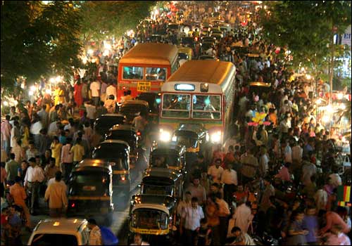
           As the world’s population expands past the six billion mark, it becomes more and more unevenly distributed. The great concentrations do not always occur on the most productive land; and people tend to gravitate towards what are often already large cities. In 1950 the largest metropolitan areas were all in the developed metropolitan areas were all in the developed world – New York, London, Tokyo and Paris. Now those have been over taken dramatically by Mexico City and Sao Paulo, with Shanghai, Calcutta, Bombay and Jakarta rising rapidly on the list.


                The developing world’s urban population is now larger than the total population of Europe, North America and Japan combined. Many of the cities have grown beyond the control of planners and include illegal slums that pack millions of people together and concentrate populations and disease. An estimated 600 million people in the cities of the developing world lack clean water, sanitation and secure homes. Even if living standards improve, cities seem set to expand, putting more land under concrete and producing more fumes from industry and vehicles in congested streets.

Monday, February 14, 2011

Human Impact: Riches from the Earth

              The Earth is minded for building materials, metals, chemicals and fuels. Powerful machinery, industrial processing and international trade mean that individual deposits are exploited on a scale far beyond local needs. An estimated 23 billion tones of non fuel minerals are extracted each year, about twice the amount of sediment carried each year by the world’s river systems. As a result, an estimated half a million hectares of land are scarred each year. As the most concentrated ore deposits become exhausted, lower grade ores are used, such that to produce an estimated nice million tons of copper in 1990, 990 million tons of ore had to be mined. The open cast Bingham Canyon copper mine in Utah, USA, 775m deep, is the largest human excavation in the world.


      The legacy of mining is not only the hole in the ground and the pile of spoil left behind; it can affect air and water over great distances. The Ilo smelter in Peru emits 600000 tons of Sulphur compounds each year, and cyanide in the waste affects marine life in a 20,000 hectares area. Small scale gold mining by hundreds of thousands of miners in the Amazon basin releases a estimated 100 tones of mercury into the river system each year.

Saturday, February 12, 2011

Human Impact – Interactive processes

             Mining and industry can release toxic metals and other wastes into ground water, and they release metals into the atmosphere as fine particles. They produce acidic gases, such as sulphur dioxide and nitrogen oxides and green house gases, notably carbon dioxide. Human activities, using fossil fuels, notably power generation and transport, are the biggest net emitters of green house gases since they extract the carbon from no renewable sources.
                 Farming practices result in the release of nitrates and phosphates from fertilizers and animal waste into ground water and rivers, adding to sewage already released into rivers and seas and causing blooms of algae which subsequently deplete the oxygen in water.  Although crops absorb carbon dioxide as they grow, they do not store it to the extent that a forest does, and rice cultivation and cattle rising produce another green house gas, methane. Clearance of natural vegetation releases carbon dioxide into the air and soil minerals into water and increases the likelihood of soil erosion.
                Natural systems absorb some, but not all, of the excesses of human activity. Alkaline soils can neutralize acidic gases washed out of the air; forests, grasslands and plankton can absorb carbon dioxide; some waste decomposes and some nutrients are recycled. But few human activities are sustainable in the long term.

Tuesday, February 8, 2011

Human Impact on Earth

              Human have inhabited the Earth for only a fraction of its history, yet they have changed the face of the planet. Their impact is obvious to the eye, even from the space: city lights and gas flares by night sprawling urban areas and the unnaturally straight lines of intensive agriculture by day. With other sensors, vast tracts of pollution are obvious on land, in water and in the atmosphere.
             Mapped over just a few decades, the destruction of forests, the spread of deserts, the reduction in stratospheric ozone and the increase in green house gases are dramatic. All are the result of human activity. In the past, the Earth has displayed a remarkable resilience, globally if not locally; today , an exploding population that demands ever increasing affluence may be pushing the limits of the Earth’s resources and its ability to process waste materials.

             At almost every stage the complex natural cycles between land, sea and atmosphere can be influences, augmented or upset by human activity. Most emissions follow the hydrological cycle. They can wash into ground water and rivers, dissolve in water vapor in clouds and fall again to Earth in rain.

Friday, February 4, 2011

Hurricanes, typhoons, cyclones and tornadoes

  Over very warm areas of ocean, warm, moist air starts rising so fast that it creates a region of intense low pressure beneath it, pulling warmer, moist air in from the sides. The phenomenon can develop into a vast spiraling weather system – a hurricane. Once formed, hurricanes can continue for many days. They tend to drift in the direction of the prevailing trade winds until they strike land. But then, the spiraling winds can reach speeds of 300Km/h, and the whole weather system may be 800Km across. In the middle known as the eye the air can be clear and deceptively still. But the other side of the storm is not far behind.


              Huge cumulonimbus clouds release torrential rain and the winds whip up high waves on the surface of the ocean beneath the hurricane.  The intense low pressure can temporarily raise sea levels by as much as 8m in what is known as a storm surge, which can cause serious flooding. Once hurricane is traveling over land, its supply of moist air is cut off and the storm eventually subsides.


       Storms that arise in the North Atlantic and batter the Caribbean and southeastern USA are called hurricanes. Those in the Pacific that threaten Southeast Asia are typhoons, and those in the Indian Ocean that have caused such extensive flooding and damage in the Indian subcontinent are cyclones.


                Tornadoes are also caused by rapidly rising spirals of air but they are on a much smaller scale than hurricanes, pulling air up into a thundercloud. Though affection a smaller area, they can be just as devastating as hurricanes, tearing off roofs and sucking up almost anything in their path, resulting in some surprising objects raining down later.

Monday, January 31, 2011

Clouds

                Clouds are simply accumulations of condensed water vapour in the air. But their ever changing patterns are quiet revealing as to how and why they formed and what kind of weather they are heralding. There are three basic types of clouds- first described in 1804 by the English chemist Luke Howard: cirrus clouds which are light and wispy, the word deriving from the Latin for “Curl of hair”; cumulus, meaning a pile or heap; and stratus, describing clouds that spread out in a horizontal layer.
                         The height at which clouds form is also important. Cirrus clouds are usually very high- at an altitude of more than 5000 m. their drawn out wisps are a sign of strong winds and changeable weather to come. Middle altitude cumulus clouds include the white, “cotton wool” fair weather clouds, as well as altocumulus clouds, which bring light showers of rain. If they occur at lower altitudes, cumulus clouds can build into heavy rain clouds and dark, anvil shaped cumulonimbus storm clouds. The latter can tower from 300 to 12000 meters and result in thunderstorms.

Monday, January 24, 2011

Global winds and Weather Fronts


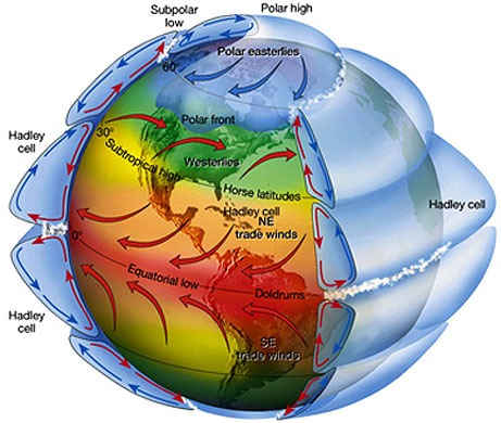
                             If the Earth were a smooth solid and not rotation, understanding wind systems would be easy. Heat would rise in the equatorial regions and warm, high level winds would blow due north and south returning towards the equator as cool winds at the surface. But the earth is spinning and has oceans and continents, hence the more, complex patterns. The earth’s rotations pull the equator bound winds to the west, creating the trade winds from the northeast in the region of the Tropic of Cancer and from the southeast at the Tropic of Capricorn. Other circulation cells provide the prevailing westerlies in the Northern Hemisphere and easterlies in the Southern Hemisphere.  This is further complicated by the continents. During the Northern Hemisphere winter, cold continental masses of Asia and North America. In July those continents are warmer and the air flow is reversed. The most spectacular example of this is the monsoon; warm, moist air blows into Asia from the Indian Ocean, depositing heavy rain as it crosses the Indian subcontinent and rises over the Himalayas.


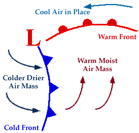
                                             Much of the weather at temperate latitudes is dominated by the interaction between masses of cold and warm air. They meet at what is known as a front, but do not mix. At a warm front, warm air rises above cold, creating a low pressure system. Moisture in the warm air builds into clouds which may produce light precipitation. At a cold front cold air wedges in under warm air, clouds build again, this time resulting in heavier, more prolonged precipitation. As the warm air rises, the front eventually combine and lift off the ground to form what is known as a occluded front. The warm air then rises more slowly, the low pressure system weakens and any precipitation eases off.

Thursday, January 20, 2011

Weather forecasting


        Weather is determined by many factors – atmospheric pressure, humidity, temperature and winds. Small, unpredictable variations in any one of these factors can have cumulative and subsequently major effects on the others and the resulting weather systems. Meteorologists are, however, getting better at prediction the weather several days in advance. To do so several  requires thousands of measurements of existing weather conditions all over the world, from manned and automatic stations on the ground and at sea, from balloons, and from satellites in space. A variety of measuring instruments are used, the most common being the thermometer and the barometer.
     

  Measurements are fed into a super computer which performs calculations based on mathematical models of typical weather system. It calculates what is likely to happen at a series of points on the ground and in the air. The closer together those points are, the more accurate the forecast will be. A weather model can contain data for millions of point in the atmosphere. Even so, details of the forecast are sometimes wrong, but forecasts can generally predict accurately up to a week in advance.

Wednesday, January 19, 2011

Climate Zones, Climate factors and Weather


There have been various systems of classifying climate, some with subsections, but essentially there are eight categories based on temperature and rainfall and thus vegetation. These are tropical, subtropical, stepped, arid, savanna, temperate, marine, continental, and mountainous and sub polar, polar. Within these there are local interactions of ocean and atmospheric circulation, continental position and relief to be considered.


Averaged out over the year, temperatures are closely zoned to latitude. Temperatures in continental interiors tend to be more extreme hotter in summer and colder in winter than latitude would indicate, where as oceans have a moderating influence cooling the tropics but warming higher latitudes. Patterns of rainfall are even more complex, although there is a tendency for continental interiors to be drier at subtropical latitudes but wetter closest to the equator.


               Climate affects whole regions and refers to weather patterns averaged out season by season over decades or even longer. Weather describes how the details of atmospheric conditions change day by day, or hour by hour, and refers to conditions at a much more local level

Tuesday, January 18, 2011

Climate & Atmospheric circulation

             Whereas the weather anywhere on Earth can fluctuate day by day, even hour by hour, in ways that are very hard to predict in detail, climate describes the general weather conditions of a location, season by season, year by year, averaged out to something that is constant and predictable. That is not to say that the climate has remained constant over geological time scales. There have been huge variations with the changing composition of the atmosphere, the output of the Sun and the changing positions of continents and ocean currents. For example, the onset of the Indian monsoon can be timed as coinciding with the initial uplift of the Himalayas which drive it. The climate is bound to change in the future too, with or without human help.


   The different regional climates on Earth are governed by atmospheric circulation and to some extent by oceans. Both are driven by heat from the Sun. the cells of atmospheric circulation reach several kilometers up into the troposphere. The deepest, called the Hadley cell, rises at the equator ad transports warm air north and south, returning cool warm air both north and south, returning cool air nearer the surface. The circulation continues across mid latitudes in the lower Ferrel cell. Above that, 5-10 Km high, and not affected by friction from the land’s surface, are jet streams. They form a series of constantly shifting waves around regions of low and high pressure.


           The Ferrel cell underneath thus becomes complicated by the Eddies. In a polar cell cold air sinks, flows out and is replaced by warmer air from above. Tropical and polar air meets at the polar front. Where warm air rises above cooler air to form a front, moisture in it condenses to form clouds and heavy rain and low pressure system that often sweeps in over Britain from the Atlantic. The position of the jet stream is important in determining whether the rain will fall on Iceland or London.

Saturday, January 15, 2011

Climate Change

       
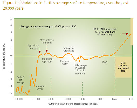
         There have clearly been many variations in the Earth’s climate over and above those produced by the cycles and wobbles of its orbit. Some changes are due to variations in the radiation reaching Earth from the Sun. over its life time so far, the Sun has been getting slowly brighter, but Earth has compensated for this by lowering carbon dioxide levels and reducing the greenhouse effect. The sun also has periods of low sunspot activity, known as Maunder minima, during which its radiation falls by a few percent. One such period caused the “little ice age” between 1530 and 1850, when fairs were held on the frozen river Thames.


            Long term trends in climate are very difficult to measure against the back ground of seasonal and annual variation. But there is evidence to suggest the average world temperatures have risen by about 0.5 degree C during the last century. This follows closely the increasing levels of carbon dioxide caused by the large scale clearing of the world’s forests and the burning of fossil fuels. Climate models in computers mostly agree that, if the present trend continues, the overall climate could warm by about 2.5 degree C by the year 2050.


         That may not seem much, but this is an average figure and local variations could be much more extreme. Some models suggest that the climate will become more polarized, with droughts in the tropics and more rainfall and storms in temperate zones.

Friday, January 14, 2011

Seasons and Climatic Cycles


        The most obvious seasonal variations on Earth are due to the 23.5 degrees inclination of the Earth’s axis to the plane of its rotation around the Sun. This produces hot summers and cold winters as a simple consequence of the different amounts of sunshine received at mid and high latitudes. Neared the equator, seasonal temperature variations are less marked than variations in rainfall, so there the year is often divided into wet and dry seasons. Sri Lanka has two rainy seasons, in spring and autumn, because the equatorial rain belt passes over it twice.


         The most spectacular season is that of the monsoon in southern Asia. Between April and October warm south westerly winds blow in off the Indian Ocean laden with moisture. This is released as extremely heavy rain when the winds rise over the heated land and begin to cool.

        There are climatic cycles over much longer timescales. The eccentricity of the Earth’s orbit varies from nearly circular to more elliptical and back over a period of about 21,000 years. It currently occurs during the Southern Hemisphere summer but that will be reversed in 10,000 years. These cycles all produce long term climatic variations.
Some Climate Extremes:
                The least sunshine occurs at the north and south poles, where the Sun does not rise for 182 days of winter.
                The maximum sunshine received is in the eastern Sahara; more than 4,300 hours a year (97% of daylight hours)
            The coldest place on an average is Plateau station, Antarctica, at -89degrees C.
            The most rainfall in 24 hours fell on Cilaos in the Indian ocean in 1952, about 1870 mm.

Thursday, January 13, 2011

Heat circulation


                  The weather system of the troposphere is constantly circulating like the cogs in a giant solar powered engine. The earth receives most solar energy around the equator and this causes evaporation and convection. Replacement air is drawn in from north and south and convection cells transfer the heat in jet streams away from the equator. They descend in a band of high pressure systems about 30degree N and 30 degree S of the equator. That produces warm southwesterly winds near the ground. As the heat continues to move out from the equator, the next series of convection cells are completed by updrafts and accompanying low pressure systems at latitudes of about 60 degree N and S. These are often associated heavy rains or snow. 
    

      The poles are capped by relatively stable, high pressure systems. At the same time, the rotation of the Earth produces the Coriolis force which deflects weather systems to the east in the Northern Hemisphere and to the west in the Southern Hemisphere. It is against the backdrop of this global heat engine  and consequent circulatory systems that weather patterns unfold.

Wednesday, January 12, 2011

An Evolving Atmosphere

            
         The first atmosphere of the Earth was very different from that of today. There was no free oxygen but high levels of carbon dioxide produced by continual volcanic eruptions. This provided the original green house effect, allowing the Earth to be warmed by the trapped rays of the Sun. By 1800million years ago oxygen began to be produced by algae photosynthesizing, and first appeared in the atmosphere.

                The amount of oxygen continued to increase but was still probably only two thirds of the present level when the first animals appeared 670 million years ago.  Only after the ozone layer formed did it become safe for animals to leave the sea and respiration became mainly aerobic.

           
    During the Mesozoic era there may have been more oxygen than today as a result of algal blooms. It cannot have been more than about 24 percent or forest fires would have raged out of control. One theory suggests that dinosaurs achieved their large size thanks to abundant oxygen ad became extinct when levels fell. The other side of the story of increasing oxygen has been one of decreasing carbon dioxide.

                
           As the Sun warmed, life kept pace with it by consuming the greenhouse gases and converting carbon dioxide into thick deposits of limestone, chalks and fossil fuels. Now humans are burning those fuels, releasing the carbon dioxide back into the air. And the forests that recycle it back into oxygen and organic matter are being felled, so the greenhouse effect is increasing. Various predictions suggest that average global temperatures could rise by several degrees as a result.

Tuesday, January 11, 2011

Atmosphere


Atmosphere
                The Earth is shrouded in a thin veil of gas called the atmosphere. At sea level it provides the air we breathe, the wind and the weather, but with increasing height, it becomes more and more rarefied, slowly blending into the virtual vacuum of space. The atmosphere has no easily defined top; technically the height at which space shuttles orbit is within the atmosphere. Our atmosphere has evolved so that there is both carbon dioxide and oxygen held in balance by photosynthesis and respiration. This combination supports life on Earth, making it unique amongst the planets of the Solar System.
Thermosphere
                Above about 450 Km any gas molecules are on their way out into space, so this is called the exosphere. Below that, down to about 80 Km
Mesosphere
                The mesosphere down to 50 Km, is too low to be warmed by direct radiation and too thin to be warmed b y convection. It includes most of the ionosphere, consisting of variable layers of atoms with one or more electrons stripped off to give them and electrical charge. Certain parts of the ionosphere can reflect shortwave radio signals and filter out X rays from space.
Stratosphere
                From about 15-50 Km above us is the stratosphere, at temperatures below 0 degree C. violent volcanic eruptions can propel gas and dust to this level, where they slowly spread around the globe. But generally, the stratosphere remains horizontally stratified, with little vertical mixing. This layer screens out most solar ultraviolet radiation.
Troposphere
                The bottom 15Km of the atmosphere, the layer in which weather condition occur, is the troposphere. It is warmed by radiation from the Earth and is therefore normally warmed from the bottom. The boundary with the stratosphere varies from about 10 Km at the poles to 20 Km at the equator.

Monday, January 10, 2011

Ocean Temperature


The top two meters of the oceans store more heat than the entire atmosphere. So the oceans are a vital buffer in keeping the Earth’s climate equitable. Still tropical waters tend to stratify as they warm, with the hottest water floating on the surface reaching temperatures of up to 25C, while 1000m down, they are a meager 5.C and below this they can plummet to 1-2 degrees.

        These layers are identified as the epilimnion, thermocline and hypolimnion.  Only when they are stirred by wind and currents r become dense due to salt to different layers mix. One possible outcome of global warming might be an even greater stratification of the oceans, polarizing climate zones still further. As it is warm ocean currents bring mild wet weather to some parts such as North West Europe, while cold currents with low evaporation rates cause cold winters in eastern Canada and desert like conditions in Chile, southwest Africa and Western Australia.

 Where cold and warm currents meet, they interact; forming eddies and fronts very similar to those of weather systems. As warm water mixes with nutrient rich cold water, ideal conditions for rapid plankton growth are created, sometimes resulting in spring blooms of Phyto-plankton.  Ocean temperatures and circulation are so important to climate that the complex computer simulations used for weather forecasting have to expend more computer power in monitoring the ocean than the atmosphere.