Monday, January 31, 2011

Clouds

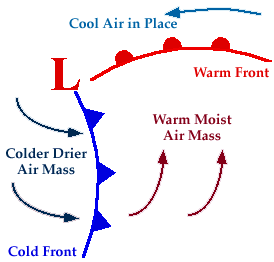
                Clouds are simply accumulations of condensed water vapour in the air. But their ever changing patterns are quiet revealing as to how and why they formed and what kind of weather they are heralding. There are three basic types of clouds- first described in 1804 by the English chemist Luke Howard: cirrus clouds which are light and wispy, the word deriving from the Latin for “Curl of hair”; cumulus, meaning a pile or heap; and stratus, describing clouds that spread out in a horizontal layer.
                         The height at which clouds form is also important. Cirrus clouds are usually very high- at an altitude of more than 5000 m. their drawn out wisps are a sign of strong winds and changeable weather to come. Middle altitude cumulus clouds include the white, “cotton wool” fair weather clouds, as well as altocumulus clouds, which bring light showers of rain. If they occur at lower altitudes, cumulus clouds can build into heavy rain clouds and dark, anvil shaped cumulonimbus storm clouds. The latter can tower from 300 to 12000 meters and result in thunderstorms.

Monday, January 24, 2011

Global winds and Weather Fronts


                             If the Earth were a smooth solid and not rotation, understanding wind systems would be easy. Heat would rise in the equatorial regions and warm, high level winds would blow due north and south returning towards the equator as cool winds at the surface. But the earth is spinning and has oceans and continents, hence the more, complex patterns. The earth’s rotations pull the equator bound winds to the west, creating the trade winds from the northeast in the region of the Tropic of Cancer and from the southeast at the Tropic of Capricorn. Other circulation cells provide the prevailing westerlies in the Northern Hemisphere and easterlies in the Southern Hemisphere.  This is further complicated by the continents. During the Northern Hemisphere winter, cold continental masses of Asia and North America. In July those continents are warmer and the air flow is reversed. The most spectacular example of this is the monsoon; warm, moist air blows into Asia from the Indian Ocean, depositing heavy rain as it crosses the Indian subcontinent and rises over the Himalayas.


                                             Much of the weather at temperate latitudes is dominated by the interaction between masses of cold and warm air. They meet at what is known as a front, but do not mix. At a warm front, warm air rises above cold, creating a low pressure system. Moisture in the warm air builds into clouds which may produce light precipitation. At a cold front cold air wedges in under warm air, clouds build again, this time resulting in heavier, more prolonged precipitation. As the warm air rises, the front eventually combine and lift off the ground to form what is known as a occluded front. The warm air then rises more slowly, the low pressure system weakens and any precipitation eases off.

Thursday, January 20, 2011

Weather forecasting


        Weather is determined by many factors – atmospheric pressure, humidity, temperature and winds. Small, unpredictable variations in any one of these factors can have cumulative and subsequently major effects on the others and the resulting weather systems. Meteorologists are, however, getting better at prediction the weather several days in advance. To do so several  requires thousands of measurements of existing weather conditions all over the world, from manned and automatic stations on the ground and at sea, from balloons, and from satellites in space. A variety of measuring instruments are used, the most common being the thermometer and the barometer.
     

  Measurements are fed into a super computer which performs calculations based on mathematical models of typical weather system. It calculates what is likely to happen at a series of points on the ground and in the air. The closer together those points are, the more accurate the forecast will be. A weather model can contain data for millions of point in the atmosphere. Even so, details of the forecast are sometimes wrong, but forecasts can generally predict accurately up to a week in advance.

Wednesday, January 19, 2011

Climate Zones, Climate factors and Weather


There have been various systems of classifying climate, some with subsections, but essentially there are eight categories based on temperature and rainfall and thus vegetation. These are tropical, subtropical, stepped, arid, savanna, temperate, marine, continental, and mountainous and sub polar, polar. Within these there are local interactions of ocean and atmospheric circulation, continental position and relief to be considered.


Averaged out over the year, temperatures are closely zoned to latitude. Temperatures in continental interiors tend to be more extreme hotter in summer and colder in winter than latitude would indicate, where as oceans have a moderating influence cooling the tropics but warming higher latitudes. Patterns of rainfall are even more complex, although there is a tendency for continental interiors to be drier at subtropical latitudes but wetter closest to the equator.


               Climate affects whole regions and refers to weather patterns averaged out season by season over decades or even longer. Weather describes how the details of atmospheric conditions change day by day, or hour by hour, and refers to conditions at a much more local level

Tuesday, January 18, 2011

Climate & Atmospheric circulation

             Whereas the weather anywhere on Earth can fluctuate day by day, even hour by hour, in ways that are very hard to predict in detail, climate describes the general weather conditions of a location, season by season, year by year, averaged out to something that is constant and predictable. That is not to say that the climate has remained constant over geological time scales. There have been huge variations with the changing composition of the atmosphere, the output of the Sun and the changing positions of continents and ocean currents. For example, the onset of the Indian monsoon can be timed as coinciding with the initial uplift of the Himalayas which drive it. The climate is bound to change in the future too, with or without human help.


   The different regional climates on Earth are governed by atmospheric circulation and to some extent by oceans. Both are driven by heat from the Sun. the cells of atmospheric circulation reach several kilometers up into the troposphere. The deepest, called the Hadley cell, rises at the equator ad transports warm air north and south, returning cool warm air both north and south, returning cool air nearer the surface. The circulation continues across mid latitudes in the lower Ferrel cell. Above that, 5-10 Km high, and not affected by friction from the land’s surface, are jet streams. They form a series of constantly shifting waves around regions of low and high pressure.


           The Ferrel cell underneath thus becomes complicated by the Eddies. In a polar cell cold air sinks, flows out and is replaced by warmer air from above. Tropical and polar air meets at the polar front. Where warm air rises above cooler air to form a front, moisture in it condenses to form clouds and heavy rain and low pressure system that often sweeps in over Britain from the Atlantic. The position of the jet stream is important in determining whether the rain will fall on Iceland or London.

Saturday, January 15, 2011

Climate Change

       
         There have clearly been many variations in the Earth’s climate over and above those produced by the cycles and wobbles of its orbit. Some changes are due to variations in the radiation reaching Earth from the Sun. over its life time so far, the Sun has been getting slowly brighter, but Earth has compensated for this by lowering carbon dioxide levels and reducing the greenhouse effect. The sun also has periods of low sunspot activity, known as Maunder minima, during which its radiation falls by a few percent. One such period caused the “little ice age” between 1530 and 1850, when fairs were held on the frozen river Thames.


            Long term trends in climate are very difficult to measure against the back ground of seasonal and annual variation. But there is evidence to suggest the average world temperatures have risen by about 0.5 degree C during the last century. This follows closely the increasing levels of carbon dioxide caused by the large scale clearing of the world’s forests and the burning of fossil fuels. Climate models in computers mostly agree that, if the present trend continues, the overall climate could warm by about 2.5 degree C by the year 2050.


         That may not seem much, but this is an average figure and local variations could be much more extreme. Some models suggest that the climate will become more polarized, with droughts in the tropics and more rainfall and storms in temperate zones.

Friday, January 14, 2011

Seasons and Climatic Cycles


        The most obvious seasonal variations on Earth are due to the 23.5 degrees inclination of the Earth’s axis to the plane of its rotation around the Sun. This produces hot summers and cold winters as a simple consequence of the different amounts of sunshine received at mid and high latitudes. Neared the equator, seasonal temperature variations are less marked than variations in rainfall, so there the year is often divided into wet and dry seasons. Sri Lanka has two rainy seasons, in spring and autumn, because the equatorial rain belt passes over it twice.


         The most spectacular season is that of the monsoon in southern Asia. Between April and October warm south westerly winds blow in off the Indian Ocean laden with moisture. This is released as extremely heavy rain when the winds rise over the heated land and begin to cool.

        There are climatic cycles over much longer timescales. The eccentricity of the Earth’s orbit varies from nearly circular to more elliptical and back over a period of about 21,000 years. It currently occurs during the Southern Hemisphere summer but that will be reversed in 10,000 years. These cycles all produce long term climatic variations.
Some Climate Extremes:
                The least sunshine occurs at the north and south poles, where the Sun does not rise for 182 days of winter.
                The maximum sunshine received is in the eastern Sahara; more than 4,300 hours a year (97% of daylight hours)
            The coldest place on an average is Plateau station, Antarctica, at -89degrees C.
            The most rainfall in 24 hours fell on Cilaos in the Indian ocean in 1952, about 1870 mm.

Thursday, January 13, 2011

Heat circulation


                  The weather system of the troposphere is constantly circulating like the cogs in a giant solar powered engine. The earth receives most solar energy around the equator and this causes evaporation and convection. Replacement air is drawn in from north and south and convection cells transfer the heat in jet streams away from the equator. They descend in a band of high pressure systems about 30degree N and 30 degree S of the equator. That produces warm southwesterly winds near the ground. As the heat continues to move out from the equator, the next series of convection cells are completed by updrafts and accompanying low pressure systems at latitudes of about 60 degree N and S. These are often associated heavy rains or snow. 
    

      The poles are capped by relatively stable, high pressure systems. At the same time, the rotation of the Earth produces the Coriolis force which deflects weather systems to the east in the Northern Hemisphere and to the west in the Southern Hemisphere. It is against the backdrop of this global heat engine  and consequent circulatory systems that weather patterns unfold.

Wednesday, January 12, 2011

An Evolving Atmosphere

            
         The first atmosphere of the Earth was very different from that of today. There was no free oxygen but high levels of carbon dioxide produced by continual volcanic eruptions. This provided the original green house effect, allowing the Earth to be warmed by the trapped rays of the Sun. By 1800million years ago oxygen began to be produced by algae photosynthesizing, and first appeared in the atmosphere.

                The amount of oxygen continued to increase but was still probably only two thirds of the present level when the first animals appeared 670 million years ago.  Only after the ozone layer formed did it become safe for animals to leave the sea and respiration became mainly aerobic.

           
    During the Mesozoic era there may have been more oxygen than today as a result of algal blooms. It cannot have been more than about 24 percent or forest fires would have raged out of control. One theory suggests that dinosaurs achieved their large size thanks to abundant oxygen ad became extinct when levels fell. The other side of the story of increasing oxygen has been one of decreasing carbon dioxide.

                
           As the Sun warmed, life kept pace with it by consuming the greenhouse gases and converting carbon dioxide into thick deposits of limestone, chalks and fossil fuels. Now humans are burning those fuels, releasing the carbon dioxide back into the air. And the forests that recycle it back into oxygen and organic matter are being felled, so the greenhouse effect is increasing. Various predictions suggest that average global temperatures could rise by several degrees as a result.

Tuesday, January 11, 2011

Atmosphere


Atmosphere
                The Earth is shrouded in a thin veil of gas called the atmosphere. At sea level it provides the air we breathe, the wind and the weather, but with increasing height, it becomes more and more rarefied, slowly blending into the virtual vacuum of space. The atmosphere has no easily defined top; technically the height at which space shuttles orbit is within the atmosphere. Our atmosphere has evolved so that there is both carbon dioxide and oxygen held in balance by photosynthesis and respiration. This combination supports life on Earth, making it unique amongst the planets of the Solar System.
Thermosphere
                Above about 450 Km any gas molecules are on their way out into space, so this is called the exosphere. Below that, down to about 80 Km
Mesosphere
                The mesosphere down to 50 Km, is too low to be warmed by direct radiation and too thin to be warmed b y convection. It includes most of the ionosphere, consisting of variable layers of atoms with one or more electrons stripped off to give them and electrical charge. Certain parts of the ionosphere can reflect shortwave radio signals and filter out X rays from space.
Stratosphere
                From about 15-50 Km above us is the stratosphere, at temperatures below 0 degree C. violent volcanic eruptions can propel gas and dust to this level, where they slowly spread around the globe. But generally, the stratosphere remains horizontally stratified, with little vertical mixing. This layer screens out most solar ultraviolet radiation.
Troposphere
                The bottom 15Km of the atmosphere, the layer in which weather condition occur, is the troposphere. It is warmed by radiation from the Earth and is therefore normally warmed from the bottom. The boundary with the stratosphere varies from about 10 Km at the poles to 20 Km at the equator.

Monday, January 10, 2011

Ocean Temperature


The top two meters of the oceans store more heat than the entire atmosphere. So the oceans are a vital buffer in keeping the Earth’s climate equitable. Still tropical waters tend to stratify as they warm, with the hottest water floating on the surface reaching temperatures of up to 25C, while 1000m down, they are a meager 5.C and below this they can plummet to 1-2 degrees.

        These layers are identified as the epilimnion, thermocline and hypolimnion.  Only when they are stirred by wind and currents r become dense due to salt to different layers mix. One possible outcome of global warming might be an even greater stratification of the oceans, polarizing climate zones still further. As it is warm ocean currents bring mild wet weather to some parts such as North West Europe, while cold currents with low evaporation rates cause cold winters in eastern Canada and desert like conditions in Chile, southwest Africa and Western Australia.

 Where cold and warm currents meet, they interact; forming eddies and fronts very similar to those of weather systems. As warm water mixes with nutrient rich cold water, ideal conditions for rapid plankton growth are created, sometimes resulting in spring blooms of Phyto-plankton.  Ocean temperatures and circulation are so important to climate that the complex computer simulations used for weather forecasting have to expend more computer power in monitoring the ocean than the atmosphere.

Saturday, January 8, 2011

The Hydrological cycle

                The world’s water is forever going to round in circles not just I ocean currents, but between atmosphere and ocean by evaporation from lakes, rivers and seas, transport in clouds precipitation as rain or snow , seepage from ground water and lakes, and flow of rivers. This is the hydrological cycle. Ninety seven percent of the world’s water is contained in oceans and saline lakes; the remaining three percent is fresh water. Three quarters of fresh water is stored as ice and nearly one quarter is in underground aquifers. All rivers, lakes and clouds contain less than one percent of the world’s fresh water, or 0.03 percent of the total

Friday, January 7, 2011

Waves and tides

 The Earth’s layer of water making up the oceans, often referred to as the hydrosphere, will according to the laws of gravity finds its own level. The Earth’s gravity however, varies over its surface according to the density of the rocks beneath; hot, low density rock, rising in a convection current through the mantle, will lead to a weaker gravitational pull and hence less water above it, where as  thick, cold, dense rock will have greater gravitational pull and so will have more water above it. This accounts for variations of several meters revealed by the satellite surveys.

The stronger influence on the height of the oceans is the gravitational pull of the Moon, which causes a bulge of ocean that is pulled towards it. A similar bulge appears on the opposite side of the globe, as if in a falling away response, which is caused by the Earths spin. The result is two high tides during the course of a day separated by about 12 hours as the Earth completes its orbits. Since the moon is also in orbit, the time of high tide varies by just under an hour each day. The sun also exerts a gravitational influence on the tides when it pulls in the same direction as the Moon the tides are at their largest and are known as spring tides. When the sun pulls at right angles to the Moon it has a diluting effect and the tidal range is less; this causes neap tides the lowest high tides.
 The surface of the ocean is constantly stirred by the wind, producing waves of transverse nature. A wave may travel for many Kilometers, and each particle of the water within it moves in a small circular motion. As the wave comes into shallow water of the shore, there is a change in speed, with the bottom of the wave slowing down at a greater rate than the top water. The top part in effect over takes the bottom, causing the wave to break. Depending on the angle at which the wave hits the shallow water, there can also be a change in direction of the wave since refraction will occur. The return flow of the water down the beach becomes a current or undertow that can be a danger to the swimmers or surfers.

Thursday, January 6, 2011

Ocean Currents and salinity

 The sea is salty. If all the oceans evaporated and the salt spread out evenly, it would form a solid layer of75 meter thick. It is likely that that the first oceans were of almost fresh water. Four billion years of rain, rivers and erosion have progressively washed more and more soluble material out of continental rocks and down to the sea.


The salinity varies widely from place to place. In the Baltic there is low evaporation and a regular input of fresh water from melting snow and its salinity is about 5000 parts per million. In the Red Sea and Persian Gulf, however, it can exceed 40,000 ppm. Salt plays an important role in the global transport of ocean currents.As water evaporates, the sea becomes saltier and as a result denser. Eventually, particularly if it cools, the salt water sinks downwards. In this way, salt and sunshine drive great conveyor belts that carry heat from equatorial waters in surface currents and return salt in deep currents.


The best example of this is in the North Atlantic, where the Gulf Stream brings rain and warm weather to western Europe and the salt returns south at depth. If this conveyor belt is disrupted, it can trigger an ice age.Ocean currents depend on the positions of the continents, and continental drift has caused major climatic change in the past.


About 30 million years ago an eastward circumpolar current established itself around Antarctica, isolating the continent from other weather systems and leading to the development of the ice cap.  A modern example of the effects of changing currents is El Nino (means The Child, so called because it occurs at Christmas) a warm current that can develop in the pacific and move towards the coast of Peru. It causes disruption to fisheries and triggers equatorial drought and tropical storms.

Wednesday, January 5, 2011

Oceans

Oceans cover 71 percent of the Earth’s surface. Since the early Earth was probably too hot for liquid water to condense, all the water in today’s oceans probably came out of volcanoes and from falling comets. Today, the oceans average more than 3500 meter in depth and the deepest part, the Mariana Trench in the Pacific, goes down 11034 meter. The shallow shelves around many continents are, geologically, extensions of those continents. They support a wide range of marine life as well as concealing extensive oil deposits.


 They are bounded by the continental slope, down which sediments fall, producing graded beds of coarse to fine sediments fall, producing graded beds of coarse to fine sediment called turbidities.


The surface of the ocean provides an important source of moisture and warmth which controls the Earth’s climate. The deep ocean floor is relatively unexplored. It has been mapped by sonar to reveal ridges, canyons, volcanoes and sea mounts. Deep sea fishing and occasional visits by submersibles exploring the cold, dark and crushing pressure of the ocean deeps provide glimpses of bizarre life forms- giant invertebrates, fish that carry their own lanterns and entire communities that never see the Sun, depending for nutrients on hot submarine springs.

Tuesday, January 4, 2011

The Soil and Soil profile

Plants and hence all life depend on the soil. Rock breaks up chemically and physically to form different soil types. The physical break up produces sand and silt, but chemical decomposition is more complex. Chalk and lime stone dissolve away leaving little residue and therefore are overlain by thin soils. Silicates on the other hand slowly react with water to form clay minerals. What happens then depends on the flow of water through the soil. If, as in temperate climates, rainfall continues through most of the year, chemicals such as iron hydroxide will tend to wash out of the top 30 cm or so, leaving a pale Grey earth, or podzol, and re depositing the iron underneath as a darker layer that can develop into an impervious hard-pan, often eliminated by ploughing. In the tropics, high rainfall during the wet season mobilizes the iron but evaporation concentrates it near the surface. During the dry season plants draw water from further down, bringing iron and aluminum hydroxide to the surface and producing red late rite. If this continues, the late rite becomes hard and impervious, making the soil infertile.
Another important soil type is the black chernosem of the steppes. During the dry summers grass draws up calcareous solutions which make the humus black and insoluble so that iron hydroxides are not leached out. Intensive agriculture can eradicate such soil profiles but the physical nature of the soil is still important. If it is sandy, it is light and easily drained but holds little organic matter and nutrients soon wash away. Clay, by contrast, is heavy and waterlogged when wet, and hard when dry, but does retain nutrients. Vegetable matter can form soil too, such as peat, which retains water well. The most fertile soils are mixture of sand and clay- loam- with plenty of organic matter. Soils are valuable and vulnerable. If exposed to acidic pollution they can release aluminum salts that poison plants and water. If vegetation s is removed they get washed away altogether.
 The uppermost layer, or topsoil, is rich in organic matter, but short of minerals. This layer is penetrated by roots and has its own established ecosystem. Beneath is the subsoil, rich in minerals but short of organic materials. Underneath is layer of weathered rock and still deeper is the unweathered bedrock.

Saturday, January 1, 2011

Landscaping by wind


On its own, wind has little effect on rocks. But let it transport sand particles and it can blast a desert landscape. Deserts tend to for m under consistently high pressure weather systems, or close to cold ocean currents which prevent evaporation into rain clouds. Clear skies expose rocks to intense heat by day and allow them to cool by night. The constant heating and cooling expands and contracts the surfaces of rocks, powering them to dust or making sheets flake off, producing smooth, rounded hills or inselbergs such as Ayers Rock in Australia.


Weathering processes produce a mixture of sand and rock and, although the popular image of a desert is of an endless expanse of sand, sandy deserts make up only 20 percent of the total. One reason is because wind whips up sand and dust and blows it away, leaving a layer of  heavier pebbles as a protective crust. The pebbles receive an intense blasting of sand which wears away the wind ward side. If the prevailing wind changes or the pebble overbalances, another side is presented and the resulting pebble has several flat faces and is known as a dreikanter.


 Where sand does dominate, it does not lie flat but builds into dunes such as barchans and seif dunes. If there is an obstacle such as a rock out crop or a bush, sand can build up in front and behind it, producing a long tail of sand in the lee of the obstacle.


Although it seldom rains in deserts, when it does occur the storms can be heavy. With little or no vegetation to retain it, the water produces flash floods which races down steep sided water courses, called wadis, scouring sand and rock as they go. Eventually this leads to a highly eroded landscape, a good example being the badlands of Arizona.